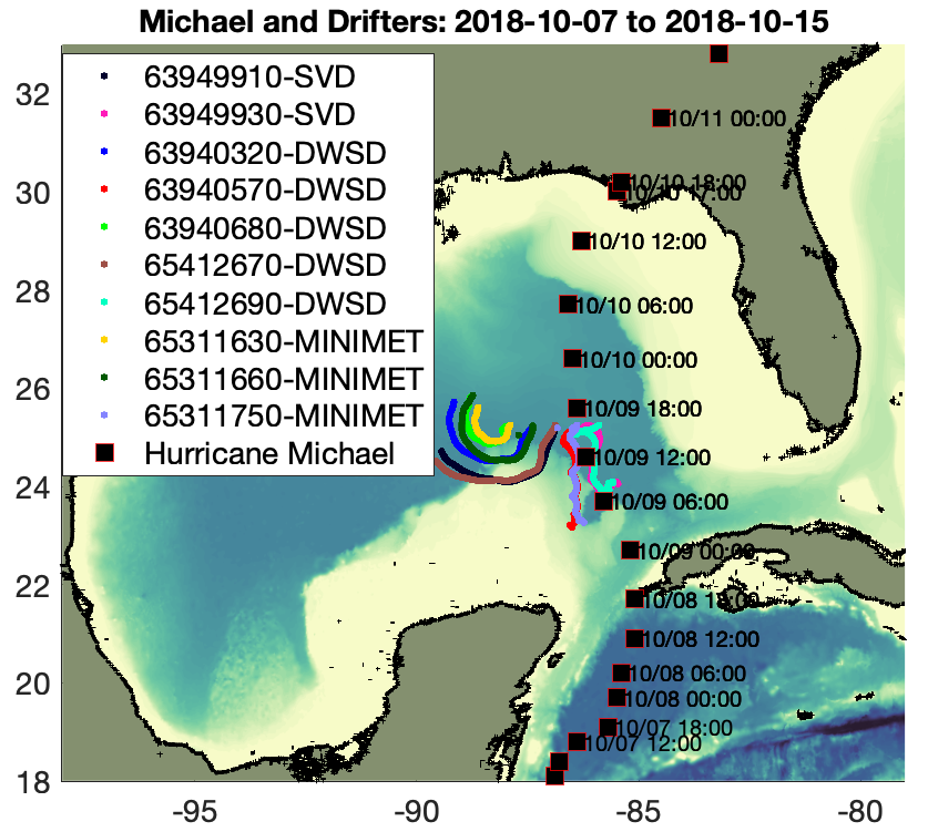
Hurricane Michael 2018
DESCRIPTION: An array of 10 surface drifters was deployed 24 hours ahead of Hurricane Michael and captured the surface temperature, pressure, wind, and directional wind-sea and swell energy across the storm center one day before it made landfall on October 10, 2018, as a Category 5 Hurricane. There were two Surface Velocity Program –Barometer Drifters (SVPBD), three MiniMet drifters, and five Directional Wave Spectra Drifters (DWSDs). Hurricane Michael encountered the array at roughly 15:00 UTC on October 9, 2018, with a minimum sea-level pressure recorded of 969 mB and extrapolated 10 m wind speeds of 26.1 m/s. Drifter directional wave spectra and drifter wind observations provide the shift of wave energy between frequency bands, and the transformation from swell to wind-sea in each quadrant of the storm. The observations are split into two data sets. The first provides the sea surface temperature, pressure, wind, and averaged wave variables of peak period and significant wave height. The second provides the first-five coefficients of the directional wave spectra.
The drifter data is described in Schönau et al. (2024). The data links are found below, as well as the link to related COAMPS-TC wind dataset used for this study. The “Sensor Data” includes observation time, latitude, longitude sea surface temperature, sea level pressure, and bulk wave parameters such as significant wave height. The “First-five Data” is for the wave energy and directional coefficients: a0, a1, b1, a2, and b2. When a wave observation is taken, the time stamps between the two files will correspond.
HOW TO USE THE DATA
This page features the Hurricane Michael data via the ERDDAP framework, with links available under the citations.
- The data are available for your use only.
- As you proceed with your analysis, please track the portion of the data that will be used in publications and communicate that information to us.
- Please cite the data as below in CITATION and provide us with the full reference(s) associated with the data DOI.
CITATION: Centurioni, L., T. Paluszkiewicz, and M. Schönau. 2022. Lagrangian Drifter Laboratory at Scripps Institution of Oceanography Hurricane Michael (2018) drifter data. Lagrangian Drifter Laboratory, Scripps Institution of Oceanography, [Data set], https://doi.org/10.57969/S94W2D.
ERDDAP SERVER LINK: https://drifterdata.ucsd.edu/erddap/tabledap/LDL_HurricaneMichael.html
CREATORS: Luca Centurioni, Theresa Paluszkiewicz, and Martha Schönau
POC: Martha Schönau
TITLE: Lagrangian Drifter Laboratory at Scripps Institution of Oceanography Hurricane Michael (2018) Drifter Data
PUBLISHER: Lagrangian Drifter Laboratory, Scripps Institution of Oceanography
PUBLICATION YEAR: 2022
DOI: 10.57969/S94W2D
RESOURCE TYPE: Dataset
GEOLOCATIONS: Gulf of Mexico (23.1°–25.9°N, 85.4°–89.6°W)
FUNDING REFERENCES:
- National Oceanic and Atmospheric Administration (NOAA) award NA20OAR432027
FIRST-FIVE DATA: Centurioni, L., T. Paluszkiewicz, and M. Schönau. 2022. Lagrangian Drifter Laboratory at Scripps Institution of Oceanography Hurricane Michael (2018) First-Five Wave Data. Lagrangian Drifter Laboratory, Scripps Institution of Oceanography. [Dataset], https://doi.org/10.57969/S9159W
ERDDAP SERVER LINK: https://drifterdata.ucsd.edu/erddap/tabledap/LDL_HurricaneMichael_First5.html
CREATORS: Luca Centurioni, Theresa Paluszkiewicz, and Martha Schönau
POC: Martha Schönau
TITLE: Lagrangian Drifter Laboratory at Scripps Institution of Oceanography Hurricane Michael (2018) Drifter Data First-Five Wave Data
PUBLISHER: Lagrangian Drifter Laboratory, Scripps Institution of Oceanography
PUBLICATION YEAR: 2022
DOI:10.57969/S9159W
RESOURCE TYPE: Dataset
GEOLOCATIONS: Gulf of Mexico (23.1°–25.9°N, 85.4°–89.6°W)
FUNDING REFERENCES:
- National Oceanic and Atmospheric Administration (NOAA) award NA20OAR432027
RELATED DATA SETS
COAMPS-TC: Schönau, M., W. Komaromi, H. Jin, J. Doyle, T. Paluszkiewicz, and L. Centurioni (Forthcoming 2024). COAMPS-TC Atmospheric Data Subset for Hurricane Michael. Dataset. Dryad. https://doi.org/10.5061/dryad.b2rbnzsp5
RELATED LITERATURE
Centurioni, L., L. Braasch, E. Di Lauro, P. Contestabile, F. De Leo, R. Casotti, L. Franco, and D. Vicinanza. 2017. A new strategic wave measurement station off Naples port main breakwater. Coastal Engineering Proceedings 1(35), waves.36, https://doi.org/10.9753/icce.v35.waves.36.
Centurioni, L.R. 2018. Drifter technology and impacts for sea surface temperature, sea-level pressure, and ocean circulation studies. Pp. 37–57 in Observing the Oceans in Real Time. R. Venkatesan, A. Tandon, E. D’Asaro and M.A. Atmanand, eds, Springer International Publishing, https://doi.org/10.1007/978-3-319-66493-4_3.
Schönau, M., T. Paluszkiewicz, Centurioni, L., Komaromi, W.A., Jin, H., and J.D. Doyle. 2024. In situ observations at the air-sea interface by expendable air-deployed drifters under Hurricane Michael (2018). Geophysical Research Letters, accepted.

CONTACT US
Lagrangian Drifter Laboratory
Scripps Institution of Oceanography
9500 Gilman Drive
La Jolla, CA 92093 USA
ldl_drifter@ucsd.edu

Lagrangian Drifter Laboratory
Scripps Institution of Oceanography
9500 Gilman Drive
La Jolla, CA 92093 USA
ldl_drifter@ucsd.edu


