Drifter-Based Science Products
Global Drifter Program and Lagrangian Drifter Laboratory scientists participate in numerous basic and applied research programs sponsored by NOAA, NASA, the Office of Naval Research, and the National Science Foundation. The LDL has crafted new drifter designs and sensor payloads to serve the needs of many science programs (e.g., NLLIWI, ASIRI, MISOBoB, NASCar, NISKINe, CALYPSO). The drifter arrays complement the observing and modeling components of the science programs and provide analytical products that support the research objectives.
- The data collected by the GDP have directly supported a large body of research that has resulted in hundreds of papers on new aspects of ocean circulations, the hydrological cycle, hurricane forecasting, and evolution of waves.
- The science supported by the publicly available sea surface temperature and sea level pressure data from GDP drifters is used by the forecast modeling community, such as the US National Weather Service and the European Centre for Medium-Range Weather Forecasts (ECMWF), as well as the ocean and atmospheric satellite community. For example, sea surface temperature data from the drifters support calibration and validation of satellite data retrievals.
Ongoing Science Programs
See our ongoing participation in international science programs such as:
CALYPSO: Coherent Lagrangian Pathways from the Surface Ocean to Interior
This Office of Naval Research Departmental Research Initiative addresses the challenges of observing, understanding, and predicting the three-dimensional pathways by which water from the surface ocean makes its way into the deeper ocean.
MISO-BOB: Monsoon Intra-seasonal Oscillations in the Tropical Indian Ocean and the Bay of Bengal
The objectives of this Office of Naval Research-sponsored experiment are to: (1) understand the ocean influence on the intensity and propagation speed (roughly 1° north per day) of the coupled ocean-atmosphere MISO signal; (2) determine how the large-scale upper ocean variability in the northern Indian Ocean, which includes shallow salinity-driven mixed layers in the north and deeper mixed layers in the south, influences the MISO signal; (3) evaluate how the submesoscale and mesoscale perturbations and processes that govern the oceanic background state communicate with and influence the MISO; and (4) integrate data and models to determine the spatial and temporal scales at which atmospheric and oceanic signatures need to be coupled to accurately capture the MISO propagation.
NISKINe: Near-Inertial Shear and Kinetic Energy in the North Atlantic Experiment
The objectives of this Office of Naval Research-sponsored experiment are to investigate the generation, evolution, and dissipation of near-inertial waves based on a variety of ship-based and autonomous observations, numerical models, and theory.
Atmospheric Rivers
The GDP supports and enhances this research program, led by CW3E, by measuring sea level atmospheric pressure with SVPB drifters to evaluate the impact of the observation in improving the forecasting of such extreme events. CW3E provides twenty-first century water cycle science, technology, and outreach to support effective policies and practices that address the impacts of extreme weather and water events on the environment, people, and the economy of western North America.
Previous Science Programs
GDP and LDL scientists participate in numerous basic and applied research programs sponsored such as:
CBLAST-DRI: Coupled Boundary Layer Air-Sea Transfer Low to Moderate Winds
The Coupled Boundary Layers Air-Sea Transfer Defense Research Initiative (CBLAST-DRI) focuses on processes that occur in the oceanic and atmospheric wave boundary layers, which are regions influenced by ocean surface waves.
CBLAST Air-Sea Exchange in Hurricanes: Coupled Boundary Layer Air-Sea Transfer
The hurricane component of the Office of Naval Research CBLAST Departmental Research Initiative aims to measure, analyze, understand and parameterize air-sea fluxes in the hurricane environment.
ITOP: Impact of Typhoons on the Ocean in the Pacific
The ITOP program is a multi-national field campaign that aims to study the ocean response to typhoons in the western Pacific Ocean.
NASCar: Northern Arabian Sea Circulation-Autonomous Research
A program that aims to elucidate the role of upper-ocean processes and atmospheric feedbacks in setting the sea surface temperature properties in the Arabian Sea region.
NLIWI: Nonlinear Internal Waves Initiative
This Office of Naval Research-supported observational program called the Nonlinear Internal Waves Initiative (NLIWI) was launched to better understand the dynamics and propagation of large-amplitude internal waves in the South China Sea in collaboration with scientists from Taiwan and the Philippines.
IWISE: The Internal Waves in Straits Experiment
Conceived as a continuation of NLIWI, the Internal Waves in Straits Experiment (IWISE) focused of the generation of the large-amplitude internal waves in the Luzon Strait and their interactions with the Kuroshio Current and other mesoscale flow structures.
OKMC: Origins of the Kuroshio and Mindanao Current
The Origins of the Kuroshio and Mindanao Currents (OKMC) observational study aimed at understanding the ocean’s circulation in the bifurcation region of the Kuroshio and Mindanao Currents, where the westward-flowing North Equatorial Current nears the Philippine coast and bifurcates into the northward-flowing Kuroshio Current and the southward-flowing Mindanao Current.
SPURS: Salinity Processes in the Upper Ocean Regional Study
The NASA-supported experiments address the essential role of the ocean in the global water cycle using a plethora of oceanographic equipment and technology, including salinity-sensing satellites, research cruises, floats, drifters, autonomous gliders and moorings.
Selected Scientific Results
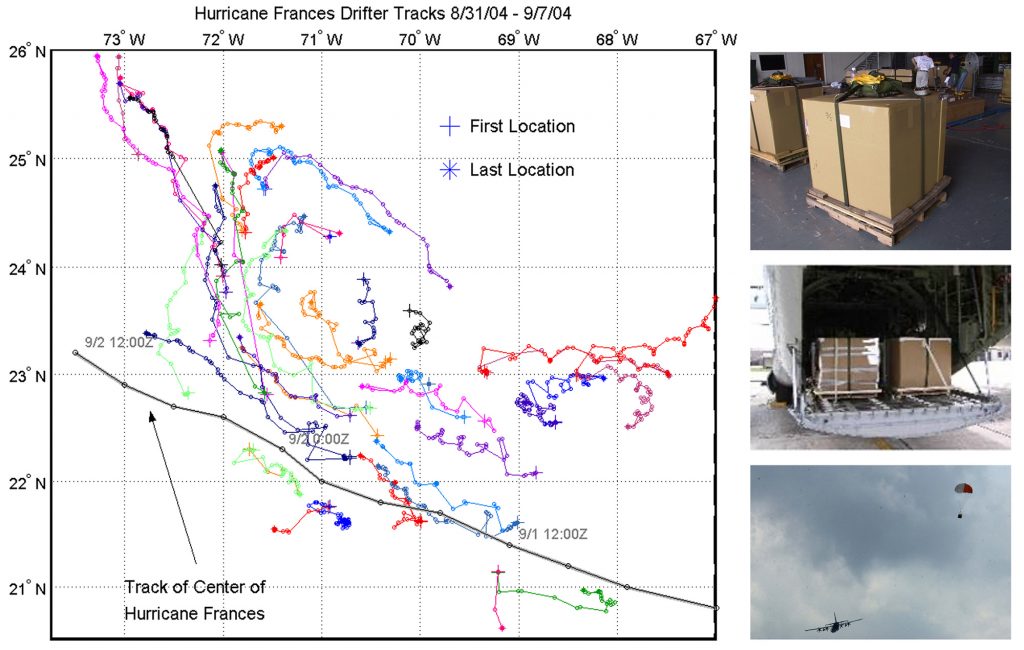
Tracking Hurricane Frances Using Air-Deployed Drifter Observations
CREDIT: From Niiler, 2008; Air-deployed drifter observations of hurricane structure and ocean response; CBLAST Presentation (2003–2007).
Under the sponsorship of the ONR Coupled Boundary Layer Air-Sea Transfer (CBLAST) program, a multitude of Surface Velocity Program drifters were air-deployed from the US Air Force Weather Reconnaissance C130 aircraft (right panels). These drifters follow the upper water column via the approximately 6 m long holey sock drogue that is centered at 15 m; they also measure sea surface temperature (SST) (see the Educational Tidbits for more explanation). The drifting thermistor chains (ADOS), however, are not designed to follow the ocean currents and instead measure the thermal stratification of the upper ocean in a semi-Lagrangian frame of reference. The drifters are deployed in front of the expected path of the hurricane, and their trajectories, mapped via their positions, show the effects of the hurricane wind field on the ocean currents as well as the surface temperature (left panel). The curves in the trajectories show the inertial rotational response of the ocean currents as well as the entrainment of the surface water along the direction of the hurricane’s track. The protocol for drifter deployment that was established during CBLAST is still used today.
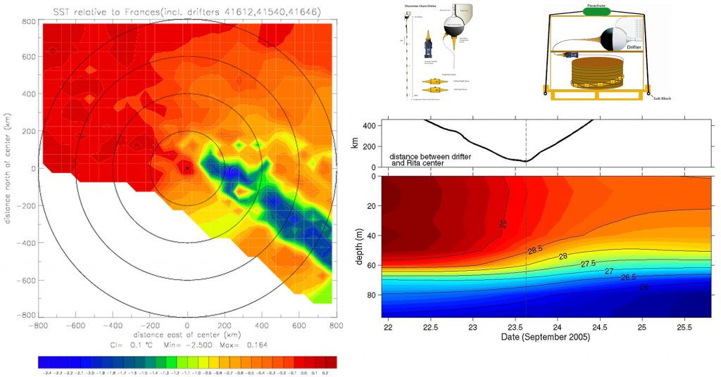
Using ADOS to Observe Changes in Sea Surface Temperature and Underlying Thermal Structure
The Autonomous Drifting Ocean Station (ADOS) facilitates the concurrent measurement of sea surface variables such as temperature, wind, and pressure and subsurface thermal structure. The diagrams at the upper right show the basic ADOS and its packaging for air deployment from a Weather Reconnaissance Aircraft C130 flown by the US Air Force “Hurricane Hunters.” The data were collected during the ONR CBLAST program. The figure on the left shows sea surface temperature constructed from a field of drifters (SVPs and ADOS), with the underlying thermal structure (plot on the right) derived from the ADOS only. The sea surface temperatures (SSTs) are from Hurricane Frances and show the cold wake from the passage of the storm (August 2004), and the subsurface data are from Hurricane Rita (2005). These figures illustrate the potential of using a field of SVPB drifters together with ADOS.
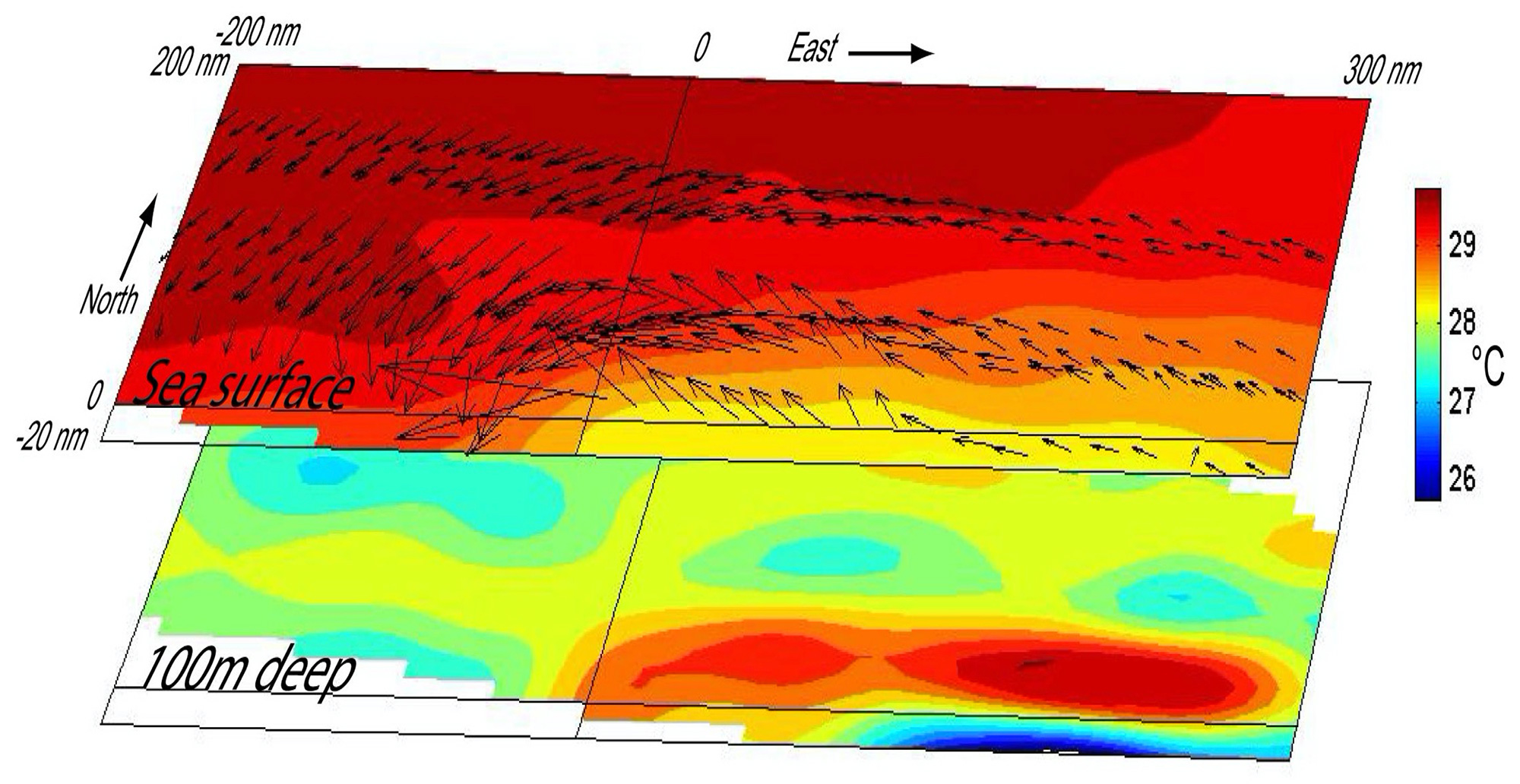
Observing Changes in Sea Surface Temperature During Hurricane Dean
CREDIT: From Niiler, 2008; Air-deployed drifter observations of hurricane structure and ocean response; CBLAST Presentation (2003–2007).
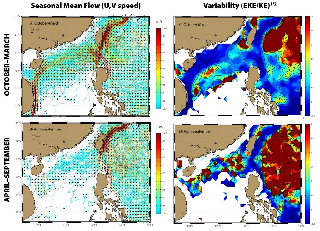
Computing Streaklines and Eddy Kinetic Energy in the Western Pacific Ocean
Data from drifters (SVP and others) in the Western Pacific Ocean are often used to plot streaklines that can very effectively display how the surface currents are organized. They are also used with sea level anomalies from AVISO and other data to compute eddy kinetic energy and its variability.
(left panels) The statistics from six-hourly SVP drifter location data are color coded in accordance with their instantaneous speeds in order to produce the streak lines that illustrate the faster and slower currents measured by the SVP drifters. The data are separated into two seasonal periods roughly corresponding to monsoon and non-monsoon seasons. Thus, the streak lines show the mean and variability of the currents. (right panels) Maps of eddy kinetic energy variability computed by the (EKE/KE)^1/2.
CREDIT: From Centurioni, L.R., P.Vélez-Belchí, J. McClean, and B. Cournelle. 2011. Observations of Kuroshio Intrusions on the East China Sea Shelf with Lagrangian drifters. Presentation at an Office of Naval Research Program Review
REFERENCE: Centurioni, L.R., P.P. Niiler, and D.K. Lee. 2009. Near-surface circulation in the South china Sea during the winter monsoon. Geophysical Research Letters 36, https://doi.org/10.1029/2008GL037076.
Internal Wave Changes Along the ADOS Array in the South China Sea
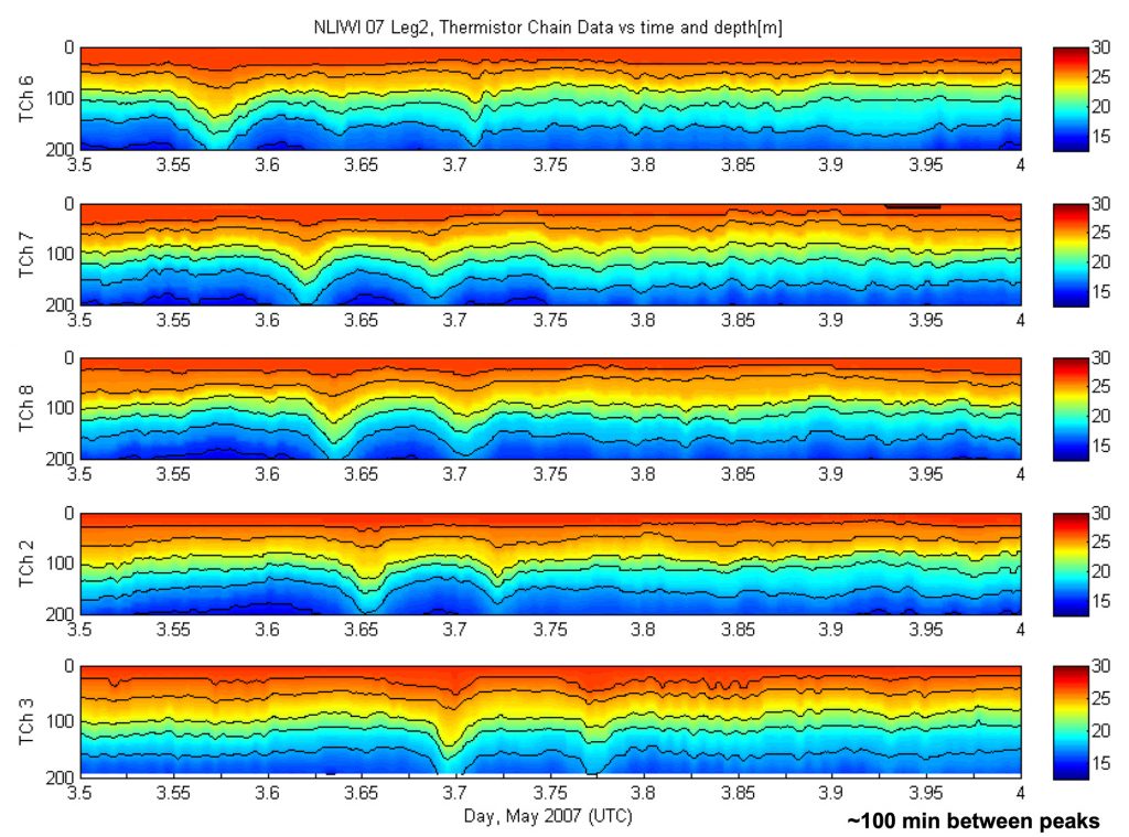
Observations of three wave groups from isotherm displacement. The following isotherms are shown: 258°, 22.58°, 208°, 17.58°, and 158°C. (bottom) Speed of the ADOS Array from GPS positions (blue: 1 s data; red: 30 s running averaged data). (left to right) Data are plotted as time series relative to the drifting instrument.
REFERENCE: Centurioni, L.R. 2010. Observations of large-amplitude nonlinear internal waves from a drifting array: Instruments and methods. Journal of Atmospheric and Oceanic Technology 27(10):1,711–1,731, https://doi.org/10.1175/2010JTECHO774.1.
Use of Velocity from Drifters for Computation of Tides
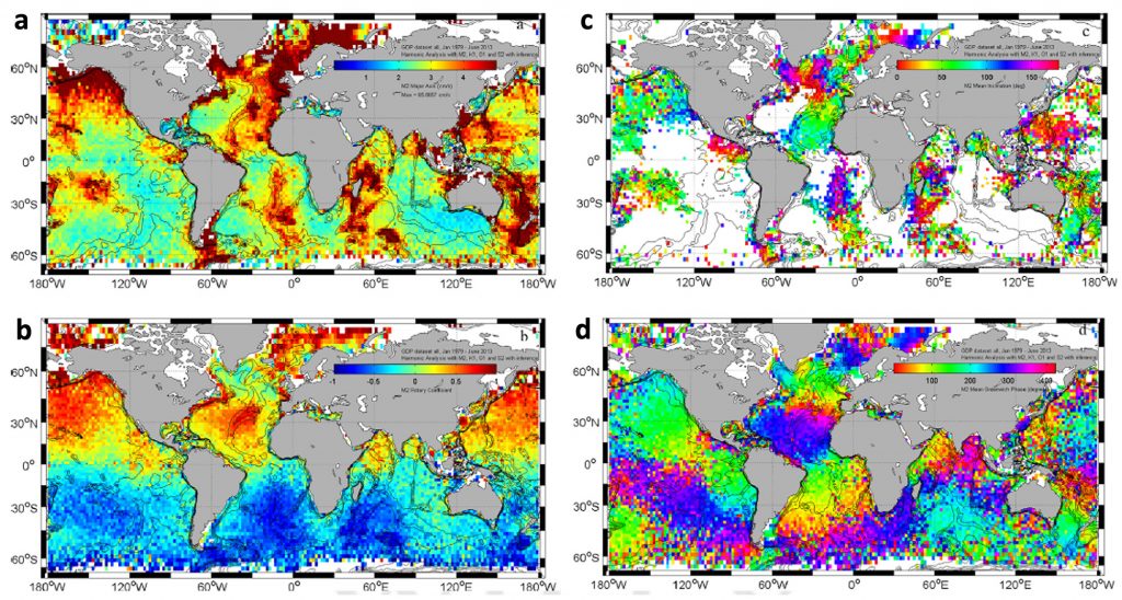
New exciting analyses are emerging by using the inertial and super-inertial velocity information in the global drifter velocity data set. Velocity data from drifters are used to compute tides. The four panels show the M2 tidal velocity, which contains both barotropic and baroclinic tidal components where the (a) mean amplitude, (b) rotary coefficient, (c) inclination, and (d) Greenwich phase of M2 tidal currents are averaged in 2º x 2º bins. Note that amplitudes in excess of 5 cm/s are saturated. For the inclination, bins with small (semi-major axis <3 cm/s), and near-circular (rotary coefficient larger than 0.9 in absolute value) tidal currents are also excluded.
CREDIT: From Poulain, P.-M., and L. Centurioni. 2015. Direct measurements of world ocean tidal currents with surface drifters. Journal of Geophysical Research: Oceans 120(10):6,986–7,003, https://doi.org/10.1002/2015JC010818.
Quantifying the Impact of In Situ Air Pressure Data from Drifters on Numerical Weather Prediction
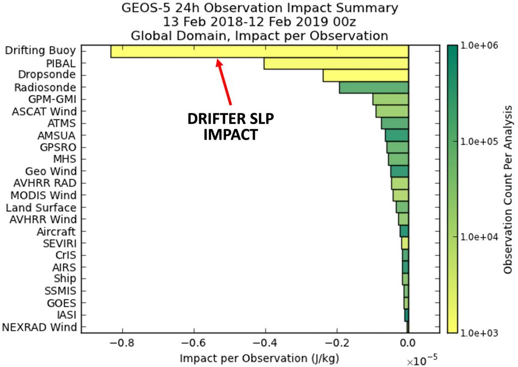
Weather and ocean forecasting benefit from drifter data, especially in the Southern Ocean where the drifters are essentially the only source of in situ sea level pressure (SLP) data. In terms of fraction of beneficial observations (or on a per observation basis) the drifter SLP data have the largest positive impact per observations when used in numerical weather prediction. Operationally, the impact of the drifter data is now measured with the adjoint model by various organizations, including NASA. Drifter SLP is particularly impactful in areas where there is very little data, such as the tropics.
CREDIT: From https://gmao.gsfc.nasa.gov/products/forecasts/systems/fp/obs_impact/. These metrics are maintained operationally.
REFERENCE: Centurioni, L., A. Horányi, C. Cardinali, E. Charpentier, and R. Lumpkin. 2016. Bulletin of the American Meteorological Society 98(2):231–238, https://doi.org/10.1175/BAMS-D-15-00080.1.
Using Drifter Data to Establish a Linkage Between Kuroshio Intrusions in the East China Sea and the Kuroshio Transport from a Sea Level Proxy
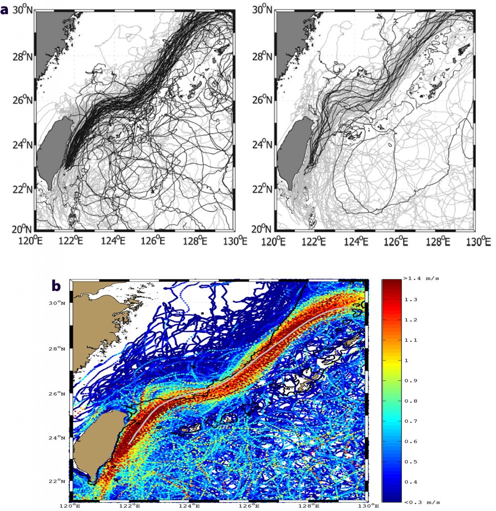
(a) The two panels show drifter tracks in the East Taiwan Channel segregated by Kuroshio transport values and extended using a proxy for the transport. Gray lines plot drfter tracks collected during the World Ocean Circulation Experiment from 1994 to 1996 (± 0.3 std from the mean). The black tracks correspond to drifters deployed between April 2008 and September 2009 during the Quantifying, Predicting, and Exploiting Uncertainty (QPE) experiment. High Kuroshio transport (left) is associated with no intrusions and low Kuroshio transport (right) is associated with intrusions. Further studies show that the intrusion of the Kuroshio Current in the East China Sea is not seasonal and is primarily driven by large cyclonic eddies that impinge on the Kuroshio and modulate its transport.
(b) The panel shows the near-surface expression of the Kuroshio from drifter tracks, color-coded by speed. The signature of the Kuroshio intrusions onto the East China Sea’s shelf, the variability of the Kuroshio off eastern Taiwan, and the signature of mesoscale eddies extending eastward can be seen in this collage of tracks.
CREDIT: Vélez-Belchí, P., L.R. Centurioni, D.-K. Lee, S. Jan, and P.P. Niiler. 2013. Eddy induced Kuroshio intrusions onto the continental shelf of the East China Sea. Journal of Marine Research 71(1–2):83–107, https://doi.org/10.1357/002224013807343470.
Using Drifter Data Together with Sea Level and Wind to Understand the Total Near-Surface Currents
CREDIT: Centurioni, L.R., P.N. Niiler. and D.K. Lee. 2009. Near-surface circulation in the South China Sea during the winter monsoon. Geophysical Research Letters 36(6), https://doi.org/10.1029/2008GL037076.
REFERENCE: Maximenko, N., P. Niiler, L. Centurioni, M.-H. Rio, O. Melnichenko, D. Chambers, V. Zlotnicki, and B. Galperin. 2009. Mean dynamic topography of the ocean derived from satellite and drifting buoy data using three different techniques. Journal of Atmospheric and Oceanic Technology 26(9):1,910–1,919, https://doi.org/10.1175/2009JTECHO672.1.
(top panels) The reconstructed seasonal sea level (mean sea level + AVISO anomaly) shows the geostrophic surface signature of the Kuroshio intrusion in (left) fall/winter (October, November, December, January) and it is contrasted with the (right) spring/summer (April, May, June, July). The mean sea level from Maximenko et al. (2009) + seasonal AVISO sea level anomaly also suggests a partially geotropically adjusted seasonal intrusion of the Kuroshio Current into the South China Sea with speeds in excess of 1 m/s. This independent computation also rules out purely Ekman-driven intrusions. Drifter streak lines (left) are color coded by speed and (right) shows distinct and localized upwelling/downwelling that occurs within the South China Sea associated with energetic features.
(lower panels) (left) Drifter speeds and (right) Ekman pumping during fall/winter (October, November, December, January). The upwelling/downwelling pattern on both sides of the Luzon Strait will likely force the axis of the Kuroshio Current to rotate more westward and into the Luzon Strait. The 15 m depth Ekman current (some 50°–60° to the right of the wind) are shown schematically and contribute to the issue; however, a simple linear superposition is probably not appropriate within the Luzon Strait. From Centurioni et al. (2009)
Seasonal Flow in the Western Arabian Sea Calculated from Drifter Speeds
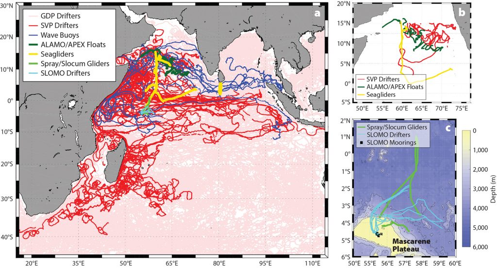
(a) Tracks and locations of Northern Arabian Sea Circulation-Autonomous Research (NASCar) autonomous assets. Details are shown of (b) the coordinated multi-platform Lagrangian drift (Region 2, and Box 3), and (c) Seychelles Local Ocean Modeling and Observations (SLOMO; Region 3).
CREDIT: From Centurioni, L.R., V. Hormann, L.D. Talley, I. Arzeno, L. Beal, M. Caruso, P. Conry, R. Echols, H.J.S. Fernando, S.N. Giddings, A. Gordon, H. Graber, R.R. Harcourt, S.R. Jayne, T.G. Jensen, C.M. Lee, P.F.J. Lermusiaux, P. L’Hegaret, A.J. Lucas, A. Mahadevan, J.L. McClean, G. Pawlak, L. Rainville, S.C. Riser, H. Seo, A.Y. Shcherbina, E. Skyllingstad, J. Sprintall, B. Subrahmanyam, E. Terrill, R.E. Todd, C. Trott, H.N. Ulloa, and H. Wang. 2017. Northern Arabian Sea Circulation-Autonomous Research (NASCar): A research initiative based on autonomous sensors. Oceanography 30(2):74–87, https://doi.org/10.5670/oceanog.2017.224.
Freshwater Export Pathways from the Bay of Bengal Determined from Drifter Trajectories
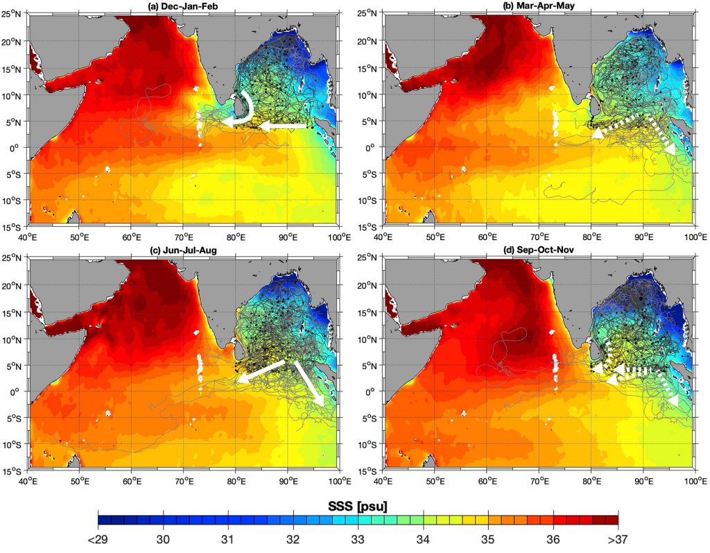
Seasonal evolution of drogued drifter trajectories from the historical Global Drifter Program archive starting within the Bay of Bengal (>3.75°N, >80°E). Black symbols mark the first drifter positions for each season, and dark gray lines illustrate the drifter trajectories during the season shown in each panel. Light gray lines indicate the trajectories after that season, overlaid on four-year mean Soil Moisture Active Passive (SMAP) sea surface salinity maps (color). (a) December-January-February (N = 150), (b) March-April-May (N = 132), (c) June-July-August (N = 189), and (d) September-October-November (N = 228). Dashed white arrows indicate export pathways out of the Bay of Bengal during the (inter-) monsoon periods. For interpretation of the references to color in this figure legend, the reader is referred to the web version of this article.
CREDIT: From Hormann, V., L.R. Centurioni, and A.L. Gordon. 2019. Freshwater export pathways from the Bay of Bengal. Deep Sea Research Part II 168:104645, https://doi.org/10.1016/j.dsr2.2019.104645
Kuroshio and Luzon Undercurrent east of Luzon Island
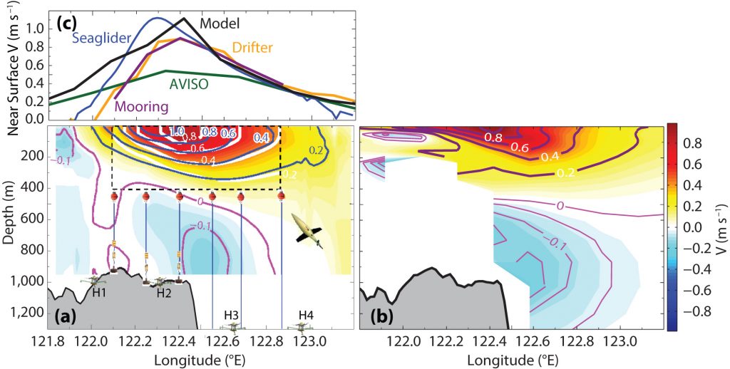
Temporal mean of the (a) observed and (b) MITgcm-OKMC optimized model meridional component of velocity of the western boundary current along 18.75°N. In panel (a), color shading and white contour lines within the dashed black box represent the average of the meridional component of the western boundary current from one year of measurements from an array of six subsurface moorings (orange dots and blue vertical lines). The color shading outside the black dashed box represents the geostrophic component of the northward western boundary current averaged from 15 sections of Seaglider measurements during the period November 2012 to May 2013. An image of the Seaglider is shown in (a). Blue and magenta contours represent northward and southward isotachs from Seaglider measurements, respectively. Schematic diagram of HPIES (a combination of horizontal electric field [HEF] sensors and pressure inverted echo sounders [PIES]) and locations are shown in (a), labeled H1–H4. A fifth HPIES (H5) located north of this section is not shown. (c) The near-surface velocity measured by Seagliders (averaged 0–10 m), moorings (averaged 0–10 m), AVISO (surface), drifters (10 m depth), and model simulations (13 m, the shallowest depth). In panels (a) and (b), isotachs are labeled with the unit of m s–1.
CREDIT: From Lien, R.-C., B. Ma, C.M. Lee, T.B. Sanford, V. Mensah, L.R. Centurioni, B.D. Cornuelle, G. Gopalakrishnan, A.L. Gordon, M.-H. Chang, S.R. Jayne, and Y.J. Yang. 2015. The Kuroshio and Luzon Undercurrent east of Luzon Island. Oceanography 28(4):54–63, https://doi.org/10.5670/oceanog.2015.81.
Important Publications
Publications on Drifter Development
Centurioni, L.R., J. C. Ohlmann, and P.P. Niiler. 2008. Permanent meanders in the California Current System. Journal of Physical Oceanography 38(8):1,690–1,710, https://doi.org/10.1175/2008JPO3746.1.
Centurioni, L., and D.-K. Lee. 2013. Introduction to the special issue on upper ocean processes: Peter Niiler’s contributions and inspirations. Oceanography 26(1):25–27, https://doi.org/10.5670/oceanog.2013.01.
Centurioni, L., A. Horányi, C. Cardinali, E. Charpentier, and R. Lumpkin. 2017. A global ocean observing system for measuring sea level atmospheric pressure: Effects and impacts on numerical weather prediction. Bulletin of the American Meteorological Society 98:231–238, https://doi.org/10.1175/BAMS-D-15-00080.1.
Centurioni, L.R., 2018. Drifter technology and impacts for sea surface temperature, sea- level pressure, and ocean circulation studies. Pp. 37–58 in Observing the Oceans in Real Time, R. Venkatesan, A. Tandon, E. D’Asaro, and M.A. Atmanand, eds, Springer Oceanography, Cham, Switzerland, https://doi.org/10.1007/978-3-319-66493-4_3.
Goni, G.J., R.E. Todd, S.R. Jayne, G. Halliwell, S. Glenn, J. Dong, R. Curry, R. Domingues, F. Bringas, L. Centurioni, S.F. DiMarco, T. Miles, J. Morell, L. Pomales, H.-S. Kim, P.E. Robbins, G.G. Gawarkiewicz, J. Wilkin, J. Heiderich, B. Baltes, J.J. Cione, G. Seroka, K. Knee, and E.R. Sanabia. 2017. Autonomous and Lagrangian ocean observations for Atlantic tropical cyclone studies and forecasts. Oceanography 30(2):92–103, https://doi.org/10.5670/oceanog.2017.227.
Lee, D.-K., and L. Centurioni. 2013. The Wintertime Subtropical Current in the northwestern Pacific. Oceanography 26(1):28–37, https://doi.org/10.5670/oceanog.2013.02.
Lumpkin, R., and L. Centurioni. 2019. Global Drifter Program quality-controlled 6-hour interpolated data from ocean surface drifting buoys. NOAA National Centers for Environmental Information data set, https://doi.org/10.25921/7ntx-z961.
Niiler, P.P., R.E. Davis, and H.J. White. 1987. Water-following characteristics of a mixed layer drifter. Deep Sea Research Part A 31:1,867–1,881, https://doi.org/10.1016/0198-0149(87)90060-4.
Niiler, P.P., A.S. Sybrandy, K. Bi, P.M. Poulain, and D. Bitterman. 1995. Measurements of the water-following capability of holey-sock and TRISTAR drifters. Deep Sea Research Part I 42:1,951–1,964, https://doi.org/10.1016/0967-0637(95)00076-3.
Pazan, S.E., and P.P. Niiler. 2001. Recovery of near-surface velocity from undrogued drifters. Journal of Atmospheric and Oceanic Technology 18:476–489, https://doi.org/10.1175/1520-0426(2001)018<0476:RONSVF>2.0.CO;2.
Black, P.G., E.A. D’Asaro, W.M. Drennan, J.R. French, P.P. Niiler, T.B. Sanford, E.J. Terrill, E.J. Walsh, and J.A. Zhang. 2007. Air-sea exchange in hurricanes – Synthesis of observations from the coupled boundary layer air-sea transfer experiment. Bulletin of the American Meteorological Society 88(3):357–374, https://doi.org/10.1175/BAMS-88-3-357.
Chen, S.S. J.F. Price, W. Zhao, M.A. Donelan, and E.J. Walsh. 2007. The CBLAST-hurricane program and the next-generation fully coupled atmosphere-wave-ocean models for hurricane research and prediction. Bulletin of the American Meteorological Society 88:311–318, https://doi.org/10.1175/BAMS-88-3-311.
D’Asaro, E.A., T.B. Sanford, P.P. Niiler, and E.J. Terrill. 2007. Cold wake of Hurricane Frances. Journal of Geophysical Research 34(15), https://doi.org/10.1029/2007GL030160.
Edson, J., T. Crawford, J. Crescenti, T. Farrar, N. Frew, G. Gerbi, C. Helmis, T. Hristov, D. Khelif, A. Jessup, H. Jonsson, M. Li, L. Mahrt, W. McGillis, A. Plueddemann, L. Shen, E. Skyllingstad, T. Stanton, P. Sullivan, J. Sun, J. Trowbridge, D. Vickers, S. Wang, Q. Wang, R. Weller, J. Wilkin, A.J. Williams III, D.K.P. Yue, and C. Zappa. 2007. The Coupled Bound-ary Layers and Air-Sea Transfer experiment in low winds. Bulletin of the American Meteorological Society 88:341–356, https://doi.org/10.1175/BAMS-88-3-341.
Price, J.F., J. Mozel, and P.P. Niiler. 2008. Warming of SST in the cool wake of a moving hurricane. Journal of Geophysical Research 113 (C7), https://doi.org/10.1029/2007JC004393.
Zedler, S.E., P.P. Niiler, D. Stammer, E. Terrill, and J. Mozel. 2009. Ocean’s response to Hurricane Frances and its implications for drag coefficient parameterization at high wind speeds. Journal of Geophysical Research 114(C4), https://doi.org/10.1029/2008JC005205.
D’Asaro, E.A., P.G. Black, L.R. Centurioni, Y.-T. Chang, S.S. Chen, R.C. Foster, H.C. Graber, P. Harr, V. Hormann, R.-C. Lien, I.-I. Lin, T.B. Sanford, T.-Y. Tang, and C.-C. Wu. 2014. Impact of typhoons on the ocean in the Pacific. Bulletin of the American Meteorological Society 95(9):1,405–1,418, https://doi.org/10.1175/BAMS-D-12-00104.1.
Hormann, V., L.R. Centurioni, L. Rainville, C.M. Lee, and L.J. Braasch. 2014. Response of upper ocean currents to Typhoon Fanapi. Geophysical Research Letters 41:3,995–4,003, https://doi.org/10.1002/2014GL060317.
Chang, Y.-C., G.-Y. Chen, R.-S. Tseng, L.R. Centurioni, and P.C. Chu. 2013. Observed near-surface flows under all tropical cyclone intensity levels using drifters in the northwestern Pacific. Journal of Geophysical Research 118:2,367–2,377, https://doi.org/10.1002/jgrc.20187.
D’Asaro, E., P. Black, L. Centurioni, P. Harr, S. Jayne, I.-I. Lin, C. Lee, J. Morzel, R. Mrvaljevic, P.P. Niiler, L. Rainville, T. Sanford, and T.Y. Tang. 2011. Typhoon-ocean interaction in the western North Pacific: Part 1. Oceanography 24(4):24–31, https://doi.org/10.5670/oceanog.2011.91.
Mrvaljevic, R.K., P.G. Black, L.R. Centurioni, Y.T. Chang, E.A. D’Asaro, S.R. Jayne, C.M. Lee, R.C. Lien, I.I. Lin, J. Morzel, P.P. Niller, L. Rainville, and T.B. Sanford. 2013. Observations of the cold wake of Typhoon Fanapi. 2010. Geophysical Research Letters 40:316–321, https://doi.org/10.1029/2012GL054282.
NLIWI and IWISE Publications
Centurioni, L.R., P.P. Niiler, and D.-K. Lee. 2004. Observations of inflow of Philippine Sea surface water into the South China Sea through the Luzon Strait. Journal of Physical Oceanography 34(1):113–121, https://doi.org/10.1175/1520-0485(2004)034<0113:OOIOPS>2.0.CO;2.
Centurioni, L.R., P.N. Niiler, and D.-K. Lee. 2009. Near-surface circulation in the South China Sea during the winter monsoon. Geophysical Research Letters 36(6), https://doi.org/10.1029/2008GL037076.
Chow, C.H., J.H. Hu, L.R. Centurioni, and P.P. Niiler. 2008. Mesoscale Dongsha cyclonic eddy in the northern South China Sea by drifter and satellite observations. Journal of Geophysical Research 113(C4), https://doi.org/10.1029/2007JC004542.
Gawarkiewicz, G., S. Jan, P.F.J. Lermusiaux, J.L. McClean, L. Centurioni, K. Taylor, B. Cornuelle, T.F. Duda, J. Wang, Y.J. Yang, T. Sanford, R.-C. Lien, C. Lee, M.-A. Lee, W. Leslie, P.J. Haley Jr., P.P. Niiler, G. Gopalakrishnan, P. Velez-Belchi, D.-K. Lee, and Y.Y. Kim. 2011. Circulation and intrusions northeast of Taiwan: Chasing and predicting uncertainty in the cold dome. Oceanography 24(4):110–121, https://doi.org/10.5670/oceanog.2011.99.
Rudnick, D.L., S. Jan, L. Centurioni, C.M. Lee, R.-C. Lien, J. Wang, D.-K. Lee, R.-S. Tseng, Y.Y. Kim, and C.-S. Chern. 2011. Seasonal and mesoscale variability of the Kuroshio near its origin. Oceanography 24(4):52–63, https://doi.org/10.5670/oceanog.2011.94.
Vélez-Belchí, P., L.R. Centurioni, D.-K. Lee, S. Jan, and P.P. Niiler. 2013. Eddy induced Kuroshio intrusions onto the continental shelf of the East China Sea. Journal of Marine Research 71(1–2):83–107, https://doi.org/10.1357/002224013807343470.
Andres, M., S. Jan, T.B. Sanford, V. Mensah, L.R. Centurioni, and J.W. Book. 2015. Mean structure and variability of the Kuroshio from northeastern Taiwan to southwestern Japan. Oceanography 28(4):84–95, https://doi.org/10.5670/oceanog.2015.84.
Gordon, A.L., P. Flament, C. Villanoy, and L. Centurioni. 2014. The nascent Kuroshio of Lamon Bay. Journal of Geophysical Research 119(7):4,251–4,263, https://doi.org/10.1002/2014JC009882.
Lee, I.H., D. Ko, Y.-H. Wang, L. Centurioni, and D.-P. Wang. 2013. The mesoscale eddies and Kuroshio transport in the western North Pacific east of Taiwan from 8-year (2003–2010) model reanalysis. Ocean Dynamics 63:1,027–1,040, https://doi.org/10.1007/s10236-013-0643-z.
Lien, R.C., B. Ma, C. Lee, T.B. Sanford, V. Mensah, L.R. Centurioni, B.D. Cornuelle, G. Gopalakrishnan, J.L. McClean, A.L. Gordon, M.H. Chang, S.R. Jayne, and Y.J. Yang. 2016. The Kuroshio and Luzon Undercurrent east of Luzon Island. Oceanography 28(4):54–63, https://doi.org/10.5670/oceanog.2015.81.
Rudnick, D. L., S. Jan, L. Centurioni, C.M. Lee, R.-C. Lien, J. Wang, D.-K. Lee, R.-S. Tseng, Y. Y. Kim, and C.-S. Chern. 2011. Seasonal and mesoscale variability of the Kuroshio near Its origin. Oceanography 24(4):52–63, https://doi.org/10.5670/oceanog.2011.94.
Yang, Y.J., S. Jan, M.-H. Chang, J. Wang, V. Mensah, T.-H. Kuo, C.-J. Tsai, C.-Y. Lee, M. Andres, L.R. Centurioni, Y.-H. Tseng, W.-D. Liang, and J.-W. Lai. 2015. Mean structure and fluctuations of the Kuroshio East of Taiwan from in situ and remote observations. Oceanography 28(4):74–83, https://doi.org/10.5670/oceanog.2015.83.
NASCar Publications
Beal, L., V. Hormann, R. Lumpkin, and G.R. Foltz. 2013. The response of the surface circulation of the Arabian Sea to monsoonal forcing. Journal of Physical Oceanography 43(9):2,008–2,022, https://doi.org/10.1175/JPO-D-13-033.1.
Centurioni, L.R., V. Hormann, L.D. Talley, I. Arzeno, L. Beal, M. Caruso, P. Conry, R. Echols, H.J.S. Fernando, S.N. Giddings, A. Gordon, H. Graber, R.R. Harcourt, S.R. Jayne, T.G. Jensen, C.M. Lee, P.F.J. Lermusiaux, P. L’Hegaret, A.J. Lucas, A. Mahadevan, J.L. McClean, G. Pawlak, L. Rainville, S.C. Riser, H. Seo, A.Y. Shcherbina, E. Skyllingstad, J. Sprintall, B. Subrahmanyam, E. Terrill, R.E. Todd, C. Trott, H.N. Ulloa, and H. Wang. 2017. Northern Arabian Sea Circulation-Autonomous Research (NASCar): A research initiative based on autonomous sensors. Oceanography 30(2):74–87, https://doi.org/10.5670/oceanog.2017.224.
Essink, S., V. Hormann, L.R. Centurioni, and A. Mahadevan. 2019. Can we detect submesoscale motions in drifter pair dispersion? Journal of Physical Oceanography 49(9):2,237–2,254, https://doi.org/10.1175/JPO-D-18-0181.1.
Hormann, V., L.R. Centurioni, A. Mahadevan, S. Essink, E.A. D’Asaro, and B. Praveen Kumar. 2016. Variability of near-surface circulation and sea surface salinity observed from Lagrangian drifters in the northern Bay of Bengal during the waning 2015 southwest monsoon. Oceanography 29(2):124–133, https://doi.org/10.5670/oceanog.2016.45.
Hormann, V., L.R. Centurioni, and A.L. Gordon. 2019. Freshwater export pathways from the Bay of Bengal. Deep Sea Research Part II 168:104645, https://doi.org/10.1016/j.dsr2.2019.104645.
Jinadasa, S.U.P, G. Pathirana, P.N. Ranasinghe, L. Centurioni, and V. Hormann. 2020. Monsoonal impact on circulation pathways in the Indian Ocean. Acta Oceanologia Sinica 39:103–112, https://doi.org/10.1007/s13131-020-1557-5.
Lee, C.M., S.U.P. Jinadasa, A. Anutaliya, L.R. Centurioni, H.J.S. Fernando, V. Hormann, M. Lankhorst, L. Rainville, U. Send, and H.W. Wijesekera. 2016. Collaborative observations of boundary currents, water mass variability, and monsoon response in the southern Bay of Bengal. Oceanography 29(2):102–111, https://doi.org/10.5670/oceanog.2016.43.
Wijesekera, H.W., E. Shroyer, A. Tandon, M. Ravichandran, D. Sengupta, S.U.P Jinadasa, H.J. S. Fernando, N. Agrawal, K. Arulananthan, G.S. Bhat, M. Baumgartner, J. Buckley, L. Centurioni, P. Conry, J.T. Farrar, A.L. Gordon, V. Hormann, E. Jarosz, T.G. Jensen, S. Johnston, M. Lankhorst, C.M. Lee, L.S. Leo, I. Lozovatsky, A.J. Lucas, J. Mackinnon, A. Mahadevan, J. Nash, M.M. Omand, H. Pham, R. Pinkel, L. Rainville, S. Ramachandran, D.L. Rudnick, S. Sarkar, U. Send, R. Sharma , H. Simmons, K.M. Stafford, L. St. Laurent, K. Venayagamoorthy, R. Venkatesan, W.J. Teague, D.W. Wang, A.F. Waterhouse, R.Weller, and C.B. Whalen. 2016. ASIRI: An ocean-atmosphere initiative for Bay of Bengal. Bulletin of the American Meteorological Society 97(10):1,859–1,884. https://doi.org/10.1175/BAMS-D-14-00197.1.
Andres, M., M. Siegelman, V. Hormann, R.C. Musgrave, S.T. Merrifield, D.L. Rudnick, M.A. Merrifield, M.H. Alford, G. Voet, H.W. Wijesekera, J.A. MacKinnon, L. Centurioni, J.D. Nash, and E.J. Terrill. 2019. Eddies, topography, and the abyssal flow by the Kyushu-Palau Ridge near Velasco Reef. Oceanography 32(4):46–55, https://doi.org/10.5670/oceanog.2019.410.
Johnston, T.M.S., M.C. Schönau, T. Paluszkiewicz, J.A. MacKinnon, B.K. Arbic, P.L. Colin, M.H. Alford, M. Andres, L. Centurioni, H.C. Graber, K.R. Helfrich, V. Hormann, P.F.J. Lermusiaux, R.C. Musgrave, B.S. Powell, B. Qiu, D.L. Rudnick, H.L. Simmons, L. St. Laurent, E.J. Terrill, D.S. Trossman, G. Voet, H.W. Wijesekera, and K.L. Zeiden. 2019. Flow Encountering Abrupt Topography (FLEAT): A multiscale observational and modeling program to understand how topography affects flows in the western North Pacific. Oceanography 32(4):10–21, https://doi.org/10.5670/oceanog.2019.407.
Centurioni, L.R., V. Hormann, Y. Chao, G. Reverdin, J. Font, and D.-K. Lee. 2015. Sea surface salinity observations with Lagrangian drifters in the tropical North Atlantic during SPURS: Circulation, fluxes, and comparisons with remotely sensed salinity from Aquarius. Oceanography 28(1):96–105, https://doi.org/10.5670/oceanog.2015.08.
Hormann, V., L.R. Centurioni, and G. Reverdin. 2015. Evaluation of drifter salinities in the subtropical North Atlantic. Journal of Atmospheric and Oceanic Technology 32(1):185–192, https://doi.org/10.1175/JTECH-D-14-00179.1.
Lindstrom, E.J., A.Y. Shcherbina, L. Rainville, J.T. Farrar, L.R. Centurioni, S. Dong, E.A. D’Asaro, C. Eriksen, D.M. Fratantoni, B.A. Hodges, V. Hormann, W.S. Kessler, C.M. Lee, S.C. Riser, L. St. Laurent, and D.L. Volkov. 2017. Autonomous multi-platform observations during the Salinity Processes in the Upper-ocean Regional Study. Oceanography 30(2):38–48, https://doi.org/10.5670/oceanog.2017.218
Rainville, L., L.R. Centurioni, W.E. Asher, C.A. Clayson, K. Drushka, J.B. Edson, B.A. Hodges, V. Hormann, J.T. Farrar, J.J. Schanze, and A.Y. Shcherbina. 2019. Novel and flexible approach to access the open ocean: Uses of sailing research vessel Lady Amber during SPURS-2. Oceanography 32(2):116–121, https://doi.org/10.5670/oceanog.2019.219
Reverdin, G., S. Morisset, L. Marié, D. Bourras, G. Sutherland, B. Ward, J. Salvador, J. Font, Y. Cuypers, L. Centurioni, V. Hormann, N. Koldziejczyk, J. Boutin, F. D’Ovidio, F. Nencioli, N. Martin, D. Diverres, G. Alory, and R. Lumpkin. 2015. Surface salinity in the North Atlantic subtropical gyre during the STRASSE/SPURS summer 2012 cruise. Oceanography 28(1):114–123, https://doi.org/10.5670/oceanog.2015.09.
Volkov, D.L., S. Dong, G.R. Foltz, G. Goni, and R. Lumpkin. 2019. Observations of near-surface salinity and temperature structure with dual-sensor Lagrangian drifters during SPURS-2. Oceanography 32(2):66–75, https://doi.org/10.5670/oceanog.2019.214.

